SEARCH Doc's Pic's picture pages

Phil and Molly's Irish Scene HOMEPAGE

HOMEPAGE for all of Phil and Molly's Pics51a. Slievemore Mountain, Deserted Village,  Megalithic Tomb, Dugort Beach, Dooniver Strand, Achill Island, Co. Mayo, Ireland (2008 and 2023)

East Keel Portal Tomb on Slievemore

[Author of Irish Scenes © Dr WP Brown PhD (plus 'DocsPics' help from AI these days), page updated November 19th 2025]

Doc Brown's Science Website biology chemistry physics

Achill Island, Co. Mayo, IrelandThe Slievemore deserted village on Achill Island

The Slievemore deserted village Achill Island, Co. Mayo, Ireland Achill Island, Co. Mayo, Ireland

Achill Island, Co. Mayo, Ireland

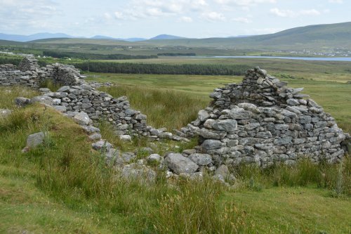
View of the deserted village houses on the 'street' track below Slievemore Mountain.


Achill Island, Co. Mayo, Ireland

-


Achill Island, Co. Mayo, Ireland


Achill Island, Co. Mayo, Ireland

The view over Keel Bay from the Deserted Village.


Achill Island, Co. Mayo, Ireland

-


Achill Island, Co. Mayo, Ireland

-


Achill Island, Co. Mayo, Ireland

-

Slievemore Deserted Village — summary and significance

The Slievemore “Deserted Village” is a linear settlement of ruined stone cottages scattered along the southern slopes of Slievemore on Achill Island, County Mayo. It is one of Ireland’s most photographed and archaeologically investigated abandoned settlements and forms a key component of the upland cultural landscape that includes field systems, burial features and post-medieval habitations.


Origins and long chronology

  • Early origins: Archaeological survey and excavation indicate a deep, multi-period occupation sequence. Structural and artefactual evidence points to an origin in the Early Medieval period (roughly AD 500–1200), with later phases of rebuilding and reuse over many centuries rather than a single short-lived settlement phase.
  • Continued use and evolution: The village’s fabric is a palimpsest: successive generations repaired, rebuilt and reconfigured house plans, yards and small fields. The visible stone cottages therefore incorporate medieval, early modern and 19th-century features layered in place.

Extent, plan and surviving fabric

  • Size and distribution: The first-edition Ordnance Survey (1838) records 137 houses in the village; modern surveys can still identify traces of about 74 structures strewn along a c.1.5 km band on the mountain slope.
  • Building form and construction: Houses are predominantly single-room, drystone-wall vernacular cottages with turf or stone-built field banks and small attached yards. Variation in house size and plan reflects long-term rebuilding and different household statuses. Robbed stones, collapse and vegetation obscure many features but the aggregate pattern remains readable as discrete habitation clusters linked by a trackway.

Economy, landscape use and household archaeology

  • Mixed upland economy: Archaeological and historic evidence point to a mixed pastoral and arable economy adapted to marginal upland conditions: small enclosed plots for tillage (potatoes, oats), animal grazing on commonage, peat-cutting and foraging. House clusters relate to discrete field systems and seasonal uses, with transhumant or seasonal movement evident in the wider landscape record.
  • Material culture: Survey and targeted excavations have produced domestic artefacts (metalwork fragments, pottery sherds, worked stone), charred plant remains and field-system features. These support a picture of household economies that adapted ancient practices through the medieval and post-medieval periods into the 19th century.

Demography and social history to abandonment

  • 19th-century population: By the early 1800s the village was occupied as a living community recorded on Ordnance Survey maps; census and estate material indicate a dense, highly marginal population dependent on potato cultivation among other subsistence activities.
  • Abandonment chronology and causes: The village did not vanish overnight; final abandonment is associated with the mid-19th-century crises (the Great Famine and its aftermath), economic decline, estate management practices and out-migration. Fieldwork indicates progressive contraction and final desertion through the later 19th century (commonly placed between the Famine years and c.1850–1890), rather than a single eviction event.

Archaeological investigation and interpretation

  • Fieldwork programme: The site has been the subject of sustained research by the Achill Archaeological Field School and others. Work includes building survey, excavation of selected houses (notably House 36), palaeoenvironmental sampling, and landscape-scale mapping of field systems and trackways.
  • Key findings: Excavation and survey have demonstrated the village’s multi-phase occupation, documented the diversity of house plans, and linked domestic deposits to long-term agrarian economies. Micromorphology, artefact sequencing and radiocarbon results have been used to refine phasing where possible.
  • Interpretive emphasis: Current archaeological interpretation stresses continuity and resilience in the community’s economy and built environment, highlighting how medieval settlement patterns persisted into the 19th century and how abandonment was a gradual, socially complex process rather than a single dramatic event.

Landscape context and associated monuments

  • Relationship to Slievemore mountain and heritage features: The village sits amid cairns, field banks, enclosure walls and megalithic and medieval sites; this interweaving of prehistoric and historic features makes Slievemore an excellent example of a long-lived ritual, agricultural and domestic landscape whose meanings changed through time.
  • Visibility and movement: The linear arrangement along contour lines and the surviving trackway structure suggest planned siting for shelter, microclimate and access to grazing, peat and water, and a clear relationship to seasonal movement across the slopes.

Conservation, public access and community value

  • Protection and management: The ruins are unroofed and exposed to weathering; management balances public access (walks, interpretation) with conservation needs. The site plays a central role in local heritage and tourism, and in teaching archaeological practice on Achill through field-school programmes.
  • Commemoration and memory: The Deserted Village is both archaeological site and cultural touchstone—its ruined rows figure in local memory, folklore and national discussions about famine, emigration and rural decline. Archaeology has reframed part of that story by emphasising long-term continuity and complexity rather than a single catastrophe.

Outstanding research questions and potential studies

  • High-resolution dating: More radiocarbon determinations across multiple houses and field contexts would tighten the phasing between medieval occupation, 18th–19th-century remodeling and final desertion.
  • Household economy and diet: Stable isotope and palaeobotanical work across several house deposits could clarify subsistence change through medieval to post-medieval periods.
  • Social causation of abandonment: Combining estate records, census data and archaeological chronologies can better resolve relative roles of famine, landlord policy and voluntary migration.
  • Landscape archaeology: LiDAR and geophysical mapping across the slope would clarify hidden field boundaries, ephemeral structures and connections to other ritual monuments.

Further reading and practical resources

  • Scholarly synthesis: Theresa McDonald’s study (International Journal of Historical Archaeology) provides a detailed archaeological account arguing for Early Medieval origins and multi-phase occupation, plus excavation results and field-system analysis.
  • Field-school resources: The Achill Archaeological Field School website summarises survey results, excavation projects and the Ordnance Survey evidence for the village’s extent and survival into the 19th century.

Achill Island, Co. Mayo, Ireland


Achill Island, Co. Mayo, Ireland

-


Achill Island, Co. Mayo, Ireland

-


East Keel Portal Tomb on the slopes of Slievemore

Keel East court tomb or Slievemore court tomb megalithic tomb on the southern slopes of Slievemore, Achill Island, Co. Mayo, Ireland

The megalithic tomb on the southern slopes of Slievemore.

Keel East court tomb or Slievemore court tomb


Achill Island, Co. Mayo, Ireland

A fine prehistoric site with a wonderful view from it!

Overview and significance

The Keel East (Slievemore) court tomb is a Neolithic megalithic burial monument located on the southern slopes of Slievemore, Achill Island, County Mayo, Ireland. It forms part of a dense archaeological landscape that includes the Slievemore deserted village and multiple other megalithic features; its upland setting and visibility make it an important local ritual focus and fieldwork target for regional archaeological projects.


Location, landscape context and site groupings

  • Location: southern slopes of Slievemore at c.152 m elevation, just east of the Slievemore deserted village; accessible by a short track from Keel East and one of a cluster of monuments on the mountain slopes.
  • Landscape role: positioned to command views across Achill’s coastal system and to sit within a palimpsest of later habitation and field systems; the tomb must be interpreted both as an isolated funerary structure and as part of a wider ritual and domestic landscape that includes historic and medieval settlement traces investigated by the Achill field school.

Sources: .


Typology, plan and architectural description

  • Type and layout: a court tomb (earlier Neolithic gallery grave) where an open forecourt leads into a gallery formed from orthostatic slabs and capped by large capstones or cairn material; Keel East actually comprises two adjoining court-tomb examples reported in the immediate area, with at least a two-chambered gallery and a substantial capstone covering the southern chamber.
  • Orientation and construction features: the monument is roughly aligned north–south; the surviving gallery shows multiple orthostats, a defined court area and evidence for a multi-chamber sequence (at least two chambers), with large capstones and cairn remnants forming the tomb’s superstructure; stone selection and positioning indicate deliberate monumental construction rather than casual stone clustering.
  • Condition: the tomb is in relatively good visible condition and readable as a court-tomb type, though weathering, later stone-robbing and post-medieval activity in the zone have affected cairn fabric and surrounding features.

Sources: .


Chronology, mortuary evidence and material culture

  • Date and use: typologically Neolithic (early/middle Neolithic horizon) and part of Ireland’s early monumental funerary tradition; court tombs are generally dated to the fourth–third millennia BCE, and Keel East fits that regional pattern though precise radiocarbon determinations for this individual monument are not widely published in popular sources.
  • Burials and deposits: as with many court tombs, original use would have involved repeated interments or curated deposits in the gallery rather than a single primary inhumation; detailed published reports of cremation/inhumation at Keel East are limited in the accessible summaries, so local excavation reports or field-school archives are the best sources for precise osteological detail.
  • Finds: surface reports note typical associated material such as worked flint, stone tools and cairn-related rubble in the locality; the site’s archaeology is best interpreted using the combined evidence of plan morphology and the finds recovered during local survey and excavation programmes.

Sources: .


Excavation, survey history and conservation

  • Recording and survey: Keel East has been recorded in national and enthusiast inventories (Megalithic Portal; MegalithicIreland) and forms part of the research remit for the Achill Archaeological Field School and local heritage bodies, which have surveyed and carried out selected excavations in the broader Slievemore landscape including the deserted village and associated monuments.
  • Conservation and visitor management: the tomb is accessible and signposted with a small car-park and track; its upland setting subjects it to weathering and visitor impact, so ongoing site recording and conservation monitoring are necessary to protect fragile orthostats and capstones.
  • Public archaeology: the site is used both as a fieldwork training resource and as part of guided local heritage interpretation that connects Neolithic monumentality with later settlement histories on Slievemore.

Research gaps, interpretive issues and directions for study

  • Gaps: precise radiocarbon dating, detailed publication of any osteological assemblage from Keel East, and comprehensive artifact catalogues are underrepresented in available online summaries; much of the refined interpretation requires consulting primary excavation reports and field-school archives.
  • Potential research directions: targeted radiocarbon and aDNA/isotope sampling (where ethical and preservationally possible) to explore mobility and kinship; micromorphology to read construction phasing within the cairn; integrated landscape survey to map the tomb’s visual, processional and resource relationships to the deserted village and nearby monuments.
  • Teaching and public outreach: Keel East is an excellent case study for court-tomb typology, upland monument placement, the archaeology of ritual landscapes, and the challenges of linking prehistoric monuments to later historic rural settlement patterns.


Achill Island, Co. Mayo, Ireland

Croaghaun from the slopes of Slievemore


Dugort Village with its lovely blue flag beach below Slievemore Mountain Achill Island, Co. Mayo, Ireland

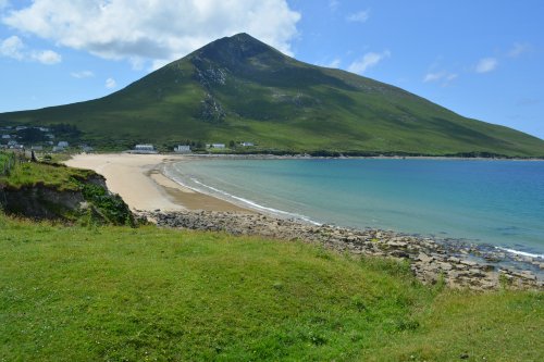
Moving on to Dugort Village with its lovely blue flag beach below Slievemore Mountain.


Achill Island, Co. Mayo, Ireland Achill Island, Co. Mayo, Ireland


Achill Island, Co. Mayo, Ireland Achill Island, Co. Mayo, Ireland

The Cottage Cafe at Dugort - excellent and frequently visited!


Achill Island, Co. Mayo, Ireland

More views of Dugort beach

Achill Island, Co. Mayo, Ireland

-


Achill Island, Co. Mayo, Ireland

-


The pier at Dugort Achill Island, Co. Mayo, Ireland

The pier at Dugort.

Achill Island, Co. Mayo, Ireland

-


Achill Island, Co. Mayo, Ireland Achill Island, Co. Mayo, Ireland

We ended up helping a boat out to see to check on the lobster pots!

Achill Island, Co. Mayo, Ireland Achill Island, Co. Mayo, Ireland


Achill Island, Co. Mayo, Ireland

The 2nd blue flag beach east of Dugort village.

Achill Island, Co. Mayo, Ireland

-


Achill Island, Co. Mayo, Ireland

Moving further east on the north side of Achill Island you come to Dooniver beach ...


Achill Island, Co. Mayo, Ireland

... where the views continue to impress!


Achill Island, Co. Mayo, Ireland

A splendid backdrop for a spot of yoga!

Achill Island, Co. Mayo, Ireland

-


Dooniver beach is safe for canoeing Achill Island, Co. Mayo, Ireland

Dooniver beach is safe for canoeing.

Achill Island, Co. Mayo, Ireland

-

Dooniver Strand-Beach, Achill Island, Co. Mayo, Ireland Dooniver Strand-Beach, Achill Island, Co. Mayo, Ireland

Dooniver Strand-Beach, Achill Island, Co. Mayo, Ireland

Dooniver Strand, Achill Island, Co. Mayo, West of Ireland, is a good picnic spot and a safe beach to swim and canoe from. The Nephin Mountains and hills across the bay look just like those in an Paul Henry west coast of Ireland painting! Dooniver beach is a place where you can practice your yoga too!

Dooniver Strand-Beach, Achill Island, Co. Mayo, Ireland

Dooniver Strand-Beach, Achill Island, Co. Mayo, Ireland


Achill Island, Co. Mayo, Ireland

Back across Achill south-west to Keel for the late afternoon.

Achill Island, Co. Mayo, Ireland

-


Achill Island, Co. Mayo, Ireland

The views of the Minaun Cliffs and Clare Island never cease to please the eye!

Achill Island, Co. Mayo, Ireland


Achill Island, Co. Mayo, Ireland

... and then back to Dooagh village.

Achill Island, Co. Mayo, Ireland

-


Achill Island, Co. Mayo, Ireland

and to our holiday cottage in Dooagh with Slievemore always our constant companion.

Achill Island, Co. Mayo, Ireland


Achill Island, Co. Mayo, Ireland

Achill Island, Co. Mayo, Ireland

Achill Island, Co. Mayo, Ireland

Slievemore Mountain (left), Achill Island, Co. Mayo, West of Ireland,  is a magnificent looking pile of quartzite ??? rocks. On its lower slopes on the southern landward side lie a deserted village (top left), a graveyard containing an ancient holy well (bottom left) and an ancient church ruin (above) and to the east a prehistoric megalithic tomb (bottom right). Its a good picnic spot, but no cafe!

Achill Island, Co. Mayo, Ireland

Achill Island, Co. Mayo, Ireland


previous page <-> next page

Phil and Molly's Irish Scenes HOMEPAGEHOMEPAGE for all of Phil and Molly's DocsPics

Irish holiday tour docspics photos images pics photographs pictures © Phil Brown * Irish holiday tours, touring in Ireland, top tourist attractions, tourism information, luxury hotels, self-catering holiday cottages, airbnb air b and b air B&B accommodation, historic towns & cities in Ireland archaeological sites, museums, cheap flights, get there by flying of Ferry, Irish Ferries, Stena Line, Ryanair Travel, dining out in Ireland, good food guide to Ireland, top Irish restaurants, Irish coach tours, weekend breaks trips to Ireland docspics images photos of Slievemore Mountain, Achill Island © Phil Brown Tourist information on Slievemore Mountain, Achill Island, Walks near Slievemore Mountain, Achill Island, Having holidays near Slievemore Mountain, Achill Island, Ireland, Top tourist attractions near Slievemore Mountain, Achill Island, luxury hotels near Slievemore Mountain, Achill Island, self-catering holiday cottages near Slievemore Mountain, Achill Island, airbnb air B and B near Slievemore Mountain, Achill Island, good B&B near Slievemore Mountain, Achill Island, friendly pubs near Slievemore Mountain, Achill Island, cafes near Slievemore Mountain, Achill Island, eating out in fine restaurants near Slievemore Mountain, Achill Island, weekend breaks near Slievemore Mountain, Achill Island, wining & dining weekends near Slievemore Mountain, Achill Island, walking holidays around Slievemore Mountain, Achill Island, touring coach tours including Slievemore Mountain, Achill Island, pretty villages near Slievemore Mountain, Achill Island, historic towns and pretty village near Slievemore Mountain, Achill Island, museums near Slievemore Mountain, Achill Island, local art galleries near Slievemore Mountain, Achill Island, guided walks from Slievemore Mountain, Achill Island, excellent fell hill walking around Slievemore Mountain, Achill Island, rambling near Slievemore Mountain, Achill Island, exploring the landscape near Slievemore Mountain, Achill Island, good places to eat near Slievemore Mountain, Achill Island, tourist attractions near Slievemore Mountain, Achill Island, tourist information for places near Slievemore Mountain, Achill Island, good places for wining and dining near Slievemore Mountain, Achill Island, good walks near Slievemore Mountain, Achill Island, properties for sale near Slievemore Mountain, Achill Island, renting a flat or house near Slievemore Mountain, Achill Island, property for rent near Slievemore Mountain, Achill Island, houses for sale near Slievemore Mountain, Achill Island, lettings near Slievemore Mountain, Achill Island, places to rent near Slievemore Mountain, Achill Island, holiday cottage accommodation near Slievemore Mountain, Achill Island

51b. A circular walk over Slievemore Mountain, Return to the Deserted Village and a return to the Cottage Cafe at Dugort Beach, Achill Island, Co. Mayo

SCENES from IRELAND

Achill Island, Co. Mayo, Ireland

One route up Slievemore mountain is to go up through the deserted village on its southern slope.


Achill Island, Co. Mayo, Ireland

-


Achill Island, Co. Mayo, Ireland

Some purple heather out as we look across to the hump of Croaghaun.


Achill Island, Co. Mayo, Ireland Achill Island, Co. Mayo, Ireland


Achill Island, Co. Mayo, Ireland

-


Achill Island, Co. Mayo, Ireland

A bit of a path through the heather!


Achill Island, Co. Mayo, Ireland

An aerial view of the deserted village and graveyard on the slopes of Slievemore.


Achill Island, Co. Mayo, Ireland

Getting near the summit of Slievemore.


Achill Island, Co. Mayo, Ireland

On the summit of Slievemore.

Achill Island, Co. Mayo, Ireland Achill Island, Co. Mayo, Ireland

Achill Island, Co. Mayo, Ireland


Achill Island, Co. Mayo, Ireland

Croagh Patrick in the centre distance.

Achill Island, Co. Mayo, Ireland

Looking down over the Cliffs of Minaun, Lough Keel and Keel Bay.


Achill Island, Co. Mayo, Ireland

Looking across from the summit of Slievemore to the summit of Croaghaun in the hazy distance.


Achill Island, Co. Mayo, Ireland

Beginning the descent to Dooega beach and village.


Achill Island, Co. Mayo, Ireland

Picking a way through the rocks.


Achill Island, Co. Mayo, Ireland

Looking back up the eastern ridge of Slievemore.


Achill Island, Co. Mayo, Ireland

-


Achill Island, Co. Mayo, Ireland

-


Achill Island, Co. Mayo, Ireland

-


Achill Island, Co. Mayo, Ireland

-

Achill Island, Co. Mayo, Ireland

-


Achill Island, Co. Mayo, Ireland Achill Island, Co. Mayo, Ireland

On the way back from walking from Dugort Village to the Deserted Village you pass the cottage where the German writer Heinrich Boll lived and worked for a period.

Heinrich Boll quotes

Achill Island, Co. Mayo, Ireland

Gathering hay the traditional way.


Achill Island, Co. Mayo, Ireland

Looking back up Slievemore.


Achill Island, Co. Mayo, Ireland

The summit of Croaghaun leads the way back and a nice hedge of fuchsia.


Achill Island, Co. Mayo, Ireland

See page 51


Fuchsia, Monbretia and Purple Loosestrife plants flowers on Achill Island, Co. Mayo, Ireland

Fuchsia, Monbretia and Purple Loosestrife.


Achill Island, Co. Mayo, Ireland

-


Achill Island, Co. Mayo, Ireland


Achill Island, Co. Mayo, Ireland

Back to the deserted village and graveyard.


Achill Island, Co. Mayo, Ireland

Achill Island, Co. Mayo, Ireland

Achill Island, Co. Mayo, Ireland

-


Achill Island, Co. Mayo, Ireland Achill Island, Co. Mayo, Ireland

An ancient Christian cross-gravestone? and a rather more 'modern' shrine.


Achill Island, Co. Mayo, Ireland

Achill Island, Co. Mayo, Ireland


Achill Island, Co. Mayo, Ireland


Achill Island, Co. Mayo, Ireland

The deserted village guided walk is a popular tourist attraction AND then we drove back to the cottage cafe in Dugort!

Achill Island, Co. Mayo, Ireland

Achill Island, Co. Mayo, Ireland

Achill Island, Co. Mayo, Ireland

Dugort Village, Achill Island, Co. Mayo, West of Ireland: Dugort village has a lovely blue flag beach (strand) for a picnic with magnificent mountain and sea views. The Kitchen Cafe has the most tempting food along with a grand pot of tea! and Tearoom (above). Above the beach and on the road towards the pier is the Strand Hotel (bottom left) for something a little stronger! All is set below Slievemore one of the highest peaks on Achill Island.

Achill Island, Co. Mayo, Ireland Achill Island, Co. Mayo, Ireland

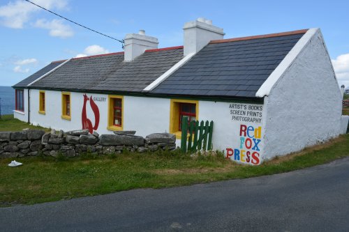
and a visit to an interesting artists workshop!

Achill Island, Co. Mayo, Ireland Achill Island, Co. Mayo, Ireland

Achill Island, Co. Mayo, Ireland  Achill Island, Co. Mayo, Ireland

Achill Island, Co. Mayo, Ireland

-

Achill Island, Co. Mayo, Ireland

A few more people on today - quite crowded!


Achill Island, Co. Mayo, Ireland

Slievemore towers above St Thomas's Church, Dugort (Church of Ireland)

Achill Island, Co. Mayo, Ireland


Achill Island, Co. Mayo, Ireland

In the evening we went to look at the reservoir above Dooagh  which supplies Achill Island with its water.

Achill Island, Co. Mayo, Ireland

This is the overflow NOT the supply!

previous page <-> next page

Phil and Molly's Irish Scenes HOMEPAGEHOMEPAGE for all of Phil and Molly's DocsPics

Irish holiday tour docspics photos images pics photographs pictures © Phil Brown * travelling touring in Ireland, top tourist attractions, tourism information, luxury hotels, self-catering holiday cottages, B&B accommodation, historic towns & cities in Ireland archaeological sites, museums, cheap flights, get there by flying , car Ferry, Irish Ferries, Stena Line, Ryanair Travel, dining out in Ireland, good food guide to Ireland, top Irish restaurants, Irish coach tours, weekend breaks trips to Ireland docspics images photos of Dugort, Achill Island © Phil Brown Tourist information on Dugort, Achill Island, Walks near Dugort, Achill Island, Having holidays near Dugort Beach and Dooniver Strand, Achill Island, Ireland, Top tourist attractions near Dugort, Achill Island, luxury hotels near Dugort, Achill Island, self-catering holiday cottages near Dugort, Achill Island, airbnb air B and B near Dugort, Achill Island, good B&B near Dugort, Achill Island, friendly pubs near Dugort, Achill Island, cafes near Dugort, Achill Island, eating out in fine restaurants near Dugort, Achill Island, weekend breaks near Dugort, Achill Island, wining & dining weekends near Dugort, Achill Island, walking holidays around Dugort, Achill Island, touring coach tours including Dugort, Achill Island, pretty villages near Dugort, Achill Island, historic towns and pretty village near Dugort, Achill Island, museums near Dugort, Achill Island, local art galleries near Dugort, Achill Island, guided walks from Dugort, Achill Island, excellent fell hill walking around Dugort, Achill Island, rambling near Dugort Beach and Dooniver Strand, Achill Island, exploring the landscape near Dugort, Achill Island, good places to eat near Dugort, Achill Island, tourist attractions near Dugort, Achill Island, tourist information for places near Dugort, Achill Island, good places for wining and dining near Dugort, Achill Island, good walks near Dugort Beach and Dooniver Strand, Achill Island, properties for sale near Dugort, Achill Island, renting a flat or house near Dugort, Achill Island, property for rent near Dugort, Achill Island, houses for sale near Dugort, Achill Island, lettings near Dugort, Achill Island, places to rent near Dugort, Achill Island, holiday cottage accommodation near Dugort, Achill Island docspics images photos of Dugort, Achill Island Ireland © Phil Brown Tourist information on Dugort, Achill Island, Things to do in Dugort, Achill Island, What to see in Dugort, Dugort Beach and Dooniver Strand Achill Island, guided walks in Dugort, Achill Island, weekend breaks in Dugort, Achill Island holidays in Dugort, Achill Island, Top tourist attractions in Dugort, Achill Island, luxury hotels in Dugort, Achill Island, self-catering holiday cottages in Dugort, Achill Island, airbnb air B and B in Dugort, Achill Island, good B&B in Dugort, Achill Island, friendly pubs in Dugort, Achill Island, cafes in Dugort, Achill Island, eating out in fine restaurants in Dugort, Achill Island, bargain holiday breaks in Dugort, Achill Island, wining & dining weekends in Dugort, Achill Island, touring coach tours visiting Dugort, Achill Island, pretty areas in Dugort, Achill Island, historic buildings in Dugort, Achill Island, visiting museums in Dugort, Achill Island, local art galleries in Dugort, Achill Island, guided walks in Dugort, Achill Island, history of Dugort, Achill Island, architecture of Dugort, Achill Island, historic houses in Dugort, Achill Island, historic churches in Dugort, Achill Island, information centre in Dugort, Achill Island, heritage places in Dugort, Achill Island, good places to eat in Dugort, Achill Island, top tourist attractions Dugort Beach and Dooniver Strand, Achill Island, tourist information for things to do and see in Dugort, Achill Island, good places to eat out in Dugort, Achill Island, good places to walk to in Dugort, Achill Island, tourist attractions properties for sale in Dugort, Achill Island, renting a flat of house in Dugort, Achill Island, property for rent in Dugort, Achill Island, houses for sale in Dugort, Achill Island, lettings in Dugort, Achill Island, places to rent in Dugort, Achill Island, holiday cottage accommodation in Dugort, Achill Island

LONDON Scenes and Notes CAMBRIDGE City England Images & Notes Selected Views of IRELAND DUBLIN Scenes and Notes SELECTED DUBLIN VIEWS Scenes from PARIS, capital city of France ITALY
Email Docs Pics CZECH REPUBLIC PRAGUE Pictures and Notes City of OXFORD Scenes & Notes HUNGARY BUDAPEST Gyor Pictures and Notes SCOTLAND - SCOTTISH Scenes and Notes LAKE DISTRICT PICTURES of England's Northern Lakeland YORK Scenes and Notes AUSTRIA-VIENNA Scenes and Notes BRISTOL images & notes

TOP OF PAGE